

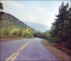
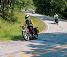
Caney Creek Loop - 40 miles


This 40 mile ride covers the extreme southern portion of the Ozark Mountains. Located about 15 miles S.W.
of Mena in the Ouachita National Forest, you find lots of twisties and elevation changes.


SOCIAL
SHARE WITH US

Copyright © 2024 - Ozark Rides, All Rights Reserved


Get Access & Benefits!
Become a Patron!
Or


![[x]](searcy to siloam springs_htm_files/close.png "Close")


Copyright © 2024 - Ozark Rides, All Rights Reserved


This 40 mile ride covers the extreme southern portion of the
Ozark Mountains. Located about 15 miles S.W. of Mena in the
Ouachita National Forest, you find lots of twisties and
elevation changes.
Step by Step Directions:
From Jct of AR-64 ans AR-81
Head southwest on County Rd 81 toward Edgewater Ln 2.92 mi
* Continue onto County Rd 79 4.44 mi * Continue onto F S 176
4.88 mi * Turn left onto Polk Rd 605 1,168 ft * Take the 1st right
onto Forest Rd 1.37 mi * Turn left onto AR-246 E 9.63 mi * Turn
left onto Shady Lake Rd 2.17 mi * Continue onto Fas 2400 4.78
mi * Slight left to stay on Fas 2400 5.42 mi * Slight left to stay
on Fas 2400 4.39 mi
Caney Creek Loop - 40 miles


Get Access & Benefits!
Become a Patron!
Or


MENU